El Trole / Los Trolebuses de
The Trolleybus System of
QUITO, ECUADOR
BY
Allen Morrison
Part 2: Centro, Av. Maldonado [Go to Part 1: Introduction, Av. 10 de Agosto]
Climbing the hill on Calle Guayaquil [see map]. The doorways on the left reveal the steep grade. View is north, toward the spires of the Basílica del Voto Nacional. Electric trams ran here from 1914 until 1948. No signage or neon is allowed in the Centro Histórico and only trolleybuses may use the lane on the left. Southbound number 24 was following circuito C1, between Estación La "Y" and Estación El Recreo, in October 2007. [Peter Haseldine]
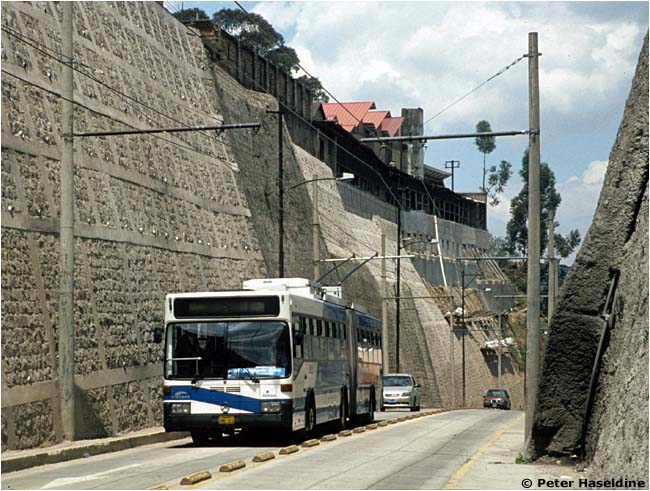
The top of the hill. Calle Guayaquil near Parada Plaza Grande [see map]. Southbound 35 was photographed in October 2007. [Peter Haseldine]
Some streets in the Centro Histórico have been taken over by El Trole completely! No other vehicles allowed. Northbound trolleybus 24 is running east on Calle Manabí, near Parada Plaza del Teatro [see map]. The stately structure with the column in the background is the Teatro Nacional. Until May 2002 northbound trolleybuses turned east on Calle Mejía, two blocks south. This photograph was taken in October 2007. [Peter Haseldine]
|


The only word on the street is "Trole"! Northbound and southbound trolleybuses and other road vehicles share the narrow lanes around Plaza Santo Domingo [see map]. The buildings on the left can be seen in the rear of the previous view. Number 65 is one of 59 new trolleybuses acquired in 1999 [see Part 3]. It was photographed in October 2007. [Peter Haseldine]
Santo Domingo Church towers over the north end of Av. Pedro Vicente Maldonado, the principal thoroughfare on the south side of town [see map]. The previous photograph was taken just around the corner in the distance. As on the plaza by the church, trolleybuses must share the pavement here with automobiles and other vehicles. [Peter Haseldine]
|


Parada Cumandá, looking north [see map]. The towers of Santo Domingo Church are visible in the upper left corner. This is one of the busiest paradas on the system because it serves Quito's intercity bus terminal. It also seems to be a popular playground. [El Comercio, Quito, 20 December 1998]
|


There are two places on the Quito trolleybus system where the route has changed since 1995. One was in the Centro Histórico, where a short section of the northbound route was moved from Calle Mejía to Calle Manabí in 2002 [see above]. The other was 1.5 km of line south of the Machángara River [see map]. Originally the line split here and southbound trolleybuses turned west from Av. Maldonado onto Calle Carlos María de la Torre, shown below. Automobiles and other vehicles were allowed to drive only north on this street. This is southbound trolleybus 9 in March 1996. [AM]
Northbound trolleybuses always ran in this area as they run today: down the hill on Av. Maldonado toward the Machángara River [see map]. But in 1996 they were the only vehicles that traveled north here; other road vehicles ran only south. Northbound 6 (later renumbered 06) at Parada Colina in March 1996. [AM]
In 2003 Av. Maldonado was rebuilt, the wires on Calle Carlos María de la Torre were removed, and thereafter trolleybuses ran in both directions on this hill section of Av. Maldonado [see map]. Other vehicles are also allowed to run here. This is trolleybus 65 in October 2007. [Peter Haseldine]
Trolleybus 04 farther south on Av. Maldonado in October 1996, when trolleybuses still ran only north [see map]. The track of the Guayaquil & Quito Railway leads to its terminal behind the photographer. Its isolated location on the top of a hill was the reason that Quito built its first tram line in 1914. Electric trams built by J. G. Brill Co. in Philadelphia were transported over these rails and later ran on this street. [Steve Morgan]
The junction of six streets at Plaza Villaflora was also rebuilt in 2003 and the parada for the trolleybuses was placed underground [see map]. There are long below-street approaches to the plaza, for trolleybuses only, on both sides. Quito has a subway! Green 09 and green 01. [Peter Haseldine]
The underground platforms at Parada Villaflora [see map]. Note the platform's height above the pavement and the folding "bridgeplate" that connects it to the trolleybus floor. The sign on the wall advises passengers to please cross at the "zebra stripes" (crosswalk). See feeder bus above. [Peter Haseldine]
|


Trolleybuses 06, 13 and 38 exchanging passengers on the platform at Estación El Recreo in October 1996 [see map]. Since about 2005, trolleybuses have run in both directions through these lanes, with high platform loading on both sides. [Steve Morgan] 
The platforms at Estación El Recreo in March 1996 [see map]. Diesel buses stop out of view on the right. The rope kept passengers in line. [AM] 
|

Go to Part 1: Introduction, Av. 10 de Agosto
Go to Part 3: "Trolesur", Quitumbe
Continue to Part 4: "El Trolebús", El Labrador
_________________________________________________________________________________________
See my index of
ELECTRIC TRANSPORT IN LATIN AMERICA
If you have comments, criticism or suggestions,
please write to Allen Morrison! Leo y escribo español.
This site was placed online on
14 March 2009
Copyright © 2009-2109 Allen Morrison
ALL RIGHTS RESERVED
TODOS LOS DERECHOS RESERVADOS